
by Judy and Don Self
For a variety of habitats in a compact area, it’s hard to beat the US Corps of Engineers Haines Island Park. Whether you’re inclined to drive, hike, canoe or kayak, Haines Island offers a fantastic opportunity to observe nature in a unique setting. Birding can be spectacular in April and May as Neotropical migrants pause to refuel in the luxuriant hardwoods of the park. The summer months offer over 100 species of breeding birds. Fall again funnels large numbers of migrants through the park. And the thick undergrowth along the lake margins shelter large flocks of finches and sparrows in winter.
Directions: From the intersection of US Highway 84 (mile marker 64.2) and Monroe County Road 39 at Claiborne, take Monroe 39 north 8.0 miles, then north on Alabama 41 for 9.2 miles, then left (west) on Monroe 17 for 2.8 miles, then right on unpaved Monroe County Road 49 to Haines Island Park and Davis Ferry and go about 1.0 miles to the park entrance.
Description: The entrance to this 480-acre park is located in a pine dominated forest atop the Buhrstone Questa (an escarpment that rises over 350 feet above the surrounding area and extends from Mississippi across western Alabama), park at the playground and picnic pavilion. From the overlook, scan the Alabama River Valley to the north for soaring Red-shouldered and Broad-winged Hawks and tree tops below for a variety of passerines.
Continue 0.5 miles northwest down the face of the questa through hardwood forest to the public boat ramp and ferry and park.
Trailheads for three hiking trails are located on either side of the elevated restroom. The Big-Leaf Magnolia Nature Trail (±0.8 miles) extends across the base of the Buhrstone Questa in the habitat of the threatened Red Hills Salamander (Alabama’s State Amphibian). The Upper Ironwood Trail branches off the Big-Leaf Magnolia trail and provides an additional ±1.1 mile of hiking and birding in mature hardwoods along the questa. The Lower Ironwood Trail is of similar length and extends down the east side of the lake. Mosquitoes and tics are common, so precautions should be taken. Red-eyed Vireo, Wood Thrush, Gray Catbird and Northern Parula are summer residents.
The riverside road that extends west from the ferry and boat ramp through the primitive camping and picnic area in the lower part of the Park occupies a narrow strip of hardwoods between the Alabama River on the northwest and a marsh and lake on the southeast. Watch for Wood Ducks, Little Blue and Great Blue Herons, Snowy and Great Egrets and White Ibis around the margin of the lake. Anhingas may be seen sunning on perches in the lake or soaring overhead. Red-headed Woodpeckers, Yellow-throated Vireos and Summer Tanagers frequent the picnic area in the summer. In winter, Carolina Wrens, American Goldfinches and Song, Swamp and White-throated Sparrows are found in the underbrush along the road. Barred owls are common at all seasons; listen in early morning and late afternoon for their “who cooks for you, who cooks for you all!”
Nutrias, large aquatic rodents introduced from South America, have invaded the lake and are a common sight.
Haines Island Park boat ramp makes an excellent put-in/take-out for paddles on the Alabama River, especially in the spring. Paddling south to Silver Creek Park (8.3 miles) or Claiborne Lake Dam Site East (10.7 miles), provides birders with the opportunity of observing wildlife along the river and in the backwaters associated with Haines Island, Camp Creek, Cane Creek, Silver Creek and Isaac Creek. It also makes an excellent take-out for paddlers coming downstream from Bells Landing Park. Ospreys, Mississippi Kites, Belted Kingfishers and Spotted Sandpipers are birds to look for on these paddles.
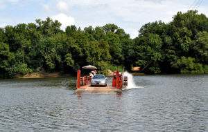
Davis Ferry is operated by the State of Alabama and runs on weekdays only from 6:30 am until noon and from 1:00 until 4:10 pm. It is free and can provide a shortcut to Thomasville and US Highway 43, but mechanical difficulties do sometimes arise.
Site Access: Free; please note that those parts of the park that are more than 300 feet from park facilities are open to hunting during hunting seasons.
GPS Coordinates: N 31° 43.248′ / W 87° 27.791′ (Park entrance); N 31° 43.473′ / W 87° 28.158′ (Trailheads)
Contact: US Army Corps of Engineers
1226 Power House Road
Camden, AL 36726
Phone: 334-682-4244
Amenities: Restrooms, Handicap access, Parking, Camping, Canoeing, Boat access, Picnic area, Hiking