
Coastal, Eastern Shore-Mobile Bay Causeway & Blakely Island Loop | Baldwin | Best Seasons: Fall | Spring
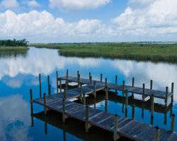
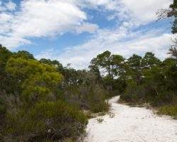
At approximately 70 acres, Village Point Park Preserve is the largest park in the city of Daphne. A parking lot with bathrooms and a picnic pavilion marks the beginning of a 3,000- foot main trail that takes visitors westward toward Mobile Bay. Along the bay are a pier and an extensive boardwalk where visitors can walk north to Bayfront Park, another Daphne city park that eBird links with Village Point as a single birding hotspot. Mixed pines and hardwoods dominate the property. Yancey Branch flows along the southern boundary of the park, and a small marsh is found near the bay.
Year-round residents include Great Horned and Barred Owls, Red-bellied and Downy Woodpeckers, Brown-headed Nuthatch and Blue-gray Gnatcatcher in the woods and Brown Pelicans and a great variety of terns and herons near the bay and marsh. In winter, a great mix of ducks are visible in the bay, although a scope can be helpful to check out the distant ones. Gadwall is the dominant winter duck, but Buffleheads are common, both scaups fairly common, and all the scoters possible. American White Pelicans appear in winter, sometimes in squadrons of more than 100, and small numbers of Horned Grebes are also present then. The spit at the north end of the beach often has a mix of shorebirds, but the best shorebird show comes when the water in the bay is low. Then, shorebirds can be abundant on mudflats offshore. Both adult and young Bald Eagles are frequently on the mudflats or in the air, sometimes right overhead, particularly in winter. Yellow-billed Cuckoos, Yellow-throated Warblers and Northern Parulas breed in the park, and other Alabama summer birds often visit.
Within Village Point Park is D’Olive Cemetery, a burial site of early Daphne settlers. This burial site dates to the early 1800s, making the D’Olives the oldest family in Daphne and one of the oldest in Baldwin County. Several graves remaining in the cemetery bear headstone inscriptions in French. In addition to its historical significance, the area near the cemetery is often excellent for migrants in spring and fall. Two paths lead through the woods from the cemetery. In spring, they often have Swainson’s Warblers, and in fall they often yield such special birds as Canada Warbler. Migrant birds can also be found near the beach, particularly by the north end of the marsh.
Jackson’s Oak, a massive Live Oak, is at the site where General Andrew Jackson is said to have once bivouacked his troops.
GPS: N30.62872 W-87.91215
Village Point Park Foundation
If following directions provided in the Coastal Birding Trail booklet, from Fairhope Municipal Park, follow Fairhope Avenue east to the center of Fairhope and turn left (north) onto US 98A (N. Section Street) [0.5]. Follow US 98A through Montrose to Daphne, turning left (west) at Village Point Park [7.9].
Amenities Available: Boardwalk, Gravel or Dirt Trails, Picnic Tables, Restrooms, Wheelchair Accessible
Nearby Sites
5 Rivers Delta Resource Center
5 Rivers sits on the banks of one of the canals that traverse the Mobile-Tensaw delta. The decks of the Delta Hall and the perimeter trail around the facility provide excellent vantage points to observe birds of the surrounding marsh and waterways. I …
Boggy Point
Boggy Point Boat Launch, an Alabama Department of Conservation and Natural Resources facility, offers a small beach with an excellent view of Robinson Island, a roosting site for herons and egrets, to the east. Robinson Island offers important habita …
Bon Secour National Wildlife Refuge – Jeff Friend Trail
The Jeff Friend Trail is a one-mile loop to Little Lagoon. Habitats include maritime forest, freshwater marsh and open water along the north shore of Little Lagoon. A variety of species are possible-waterbirds, raptors, songbirds and other passerines …
Bon Secour NWR – Mobile Street
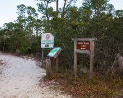
Mobile Street is a paved road leading to the beach, with a parking area for the one-mile (each way) Gator Lake Trail, which connects Mobile Street with the Pine Beach Trail. This narrow trail can be good for winter birding where you may see Blue-gray …
Bon Secour NWR – Pine Beach Trail
At the Pine Beach trailhead stands an interpretive kiosk with trail maps and bird lists. This is a two-mile trail (each way) southeastward to the beach by way of Little Lagoon and Gator Lake. The hike is an enjoyable walk through a variety of habitat …
Bon Secour River
Bon Secour Bay is found on the eastern edge of Mobile Bay and provides a protected area for wintering waterfowl and seabirds. Scan the bay and the small canal for gulls and tern. Black-crowned Night-herons may be found roosting in the oaks scattered …